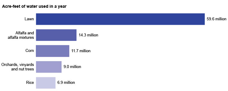
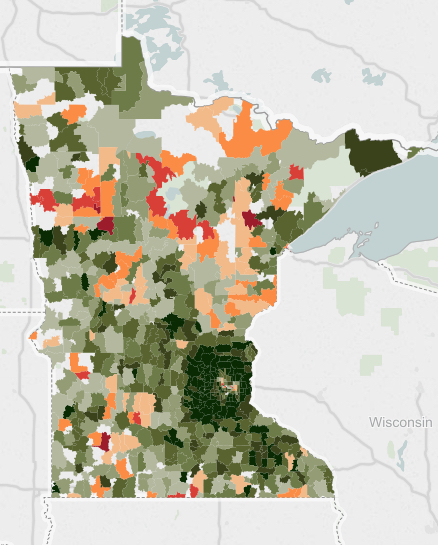
Ron Meador: Minnesota Buffer Map

MinnPost:

Apart from its importance as a reference tool for landowners and regulators, the map of Minnesota watercourses requiring protective buffers creates a fascinating new view of the state and its distinguishing natural resource.

An exercise in high-resolution and highly interactive cartography, the map and online viewer published a couple of weeks ago by the Minnesota Department of Natural Resources merges data from detailed paper maps and modern satellite imaging.

It enables a close-up look at all of the state’s lakes and streams, shown in blue in the section above, and also its public ditches, rendered in green. (The red squiggles indicate locations earmarked for ground-truthing.) You can choose to view them laid over satellite imagery of the surface, a road layout or a minimalist gray base map.

Andy McGlashen: Uninformed or the Serious Misinformed Use Lead Ammo

ENSIA:

Lead poisoning causes brain damage and, in humans, is thought to be linked with lower IQ, poor school performance and violent behavior. Even the ancient Romans knew lead could cause cognitive damage and death.

“Indeed, we know more about the toxicity of lead than we do about almost any other contaminant,” says Myra Finkelstein, an environmental toxicologist at the University of California, Santa Cruz who studies lead’s effects on wildlife.

Finkelstein was among 30 scientists who signed a 2013 consensus statement citing “the overwhelming scientific evidence of the toxic effects of lead on human and wildlife health” and calling for “reducing and eventually eliminating the introduction of lead into the environment from lead-based ammunition.”

Mondale and Roosevelt: Protect the Boundary Waters

New York Times:

MINNESOTA’S Boundary Waters Canoe Area Wilderness is one of America’s most popular wild destinations. Water is its lifeblood. Over 1,200 miles of streams wend their way through 1.1 million acres thick with fir, pine and spruce and stippled by lakes left behind by glaciers. Moose, bears, wolves, loons, ospreys, eagles and northern pike make their home there and in the surrounding Superior National Forest.

All of this is now threatened by a proposal for a huge mine to extract copper, nickel and other metals from sulfide ores. The mine would lie within the national forest along the South Kawishiwi River, which flows directly into the Boundary Waters Wilderness.

Smart people calling for action to protect a national asset.

France Diep: Water Use per Crop

ScienceLine (via street.mn chart of the day):

Homeowners have a “definitely significant” role in the nation’s water budget, says Cristina Milesi, an ecosystem modeling researcher now with NASA who led the 2005 Environmental Management study. “Each family may have only a small lawn,” she explains, “but once you add them all up they have a big impact.”

Watering the lawn generally accounts for 50 percent to 75 percent of a home’s water use during the summer. To save water and money, Milesi suggests choosing more drought resistant turf and adjusting your watering schedules to fit the weather and season. Many cities have suggested or required water schedules for different times of the year.

Some even advocate abandoning the great green lawn in favor of meadows, vegetable gardens, local native plants or just letting the grass die.

Matt Steele: Zoning Contributes to Unaffordability

streets.mn:

There’s an Ethiopian proverb that goes something like, “When spider webs unite, they can tie up a lion.” When it comes to housing, Minneapolitans may have it better than those in Seattle, San Francisco, D.C., and Brooklyn, but a larger and wider slice of Minneapolis is feeling the pinch of fast-rising rents. For some, this even means displacement or possibly even homelessness. This is unacceptable. And it doesn’t have to be this way, because we could eliminate artificial caps on housing supply in Minneapolis, thereby reducing equilibrium rents and making housing more affordable for more people. If every dwelling unit is like a little barely-visible spider web, it may seem like a unit here or two units there won’t make a big difference. But, on the whole, the economics are sound: Rising supply necessarily lowers rents.

No, I’m not going to claim that upzoning is the panacea to housing affordability. But our current zoning code is working against natural housing supply, and that’s working against housing affordability. It seems like such an easy, obvious win to get rid of the barriers to new housing stock in our city.

To understand how our zoning code is restrictive to the point of being harmful to housing affordability, let’s look at a real life example...

The reader comments to this article are worth reading as well.

Tom Neil: Minneapolis Parks -- Priority for Repair

MinnPost:

The map below shows the 106 Minneapolis parks that were recently given priority rankings (out of 157 total neighborhood parks in the city) for maintenance and improvement under the Minneapolis Park and Recreation Board’s new capital and rehabilitation plan. The parks in the darker shade of green are slated for improvements to be made in the next five years; parks in lighter green will be included in future plans. Click on a park to see its overall ranking and the projects that are planned for the park, if known. To search for an address, use the box in the upper-right corner. For more information on how the rankings were determined, see the table...

Good organization of the data on the city parks.

Kurt Chandler: Who Gets to Drink From the Great Lakes?

Atlantic:

Water has become the 21st-century equivalent of oil, and a plan to divert water from the Great Lakes to surrounding areas is raising questions about the possibility of future water grabs from far-flung water-sparse regions.

While plans to divert water from the Great Lakes basin date back to the early 1900s, modern-day attempts have become increasingly extravagant. In 1982, Congress directed the U.S. Army Corps of Engineers to study the feasibility of using Great Lakes water to irrigate farmland on the Great Plains. (Not so feasible, said the Corps.) Fifteen years later, a businessman in Canada secured a permit from the Ontario Ministry of the Environment to transport 158 million gallons of water each year from Lake Superior to Asia in tanker ships. (He withdrew his proposal in 1998 under pressure from Canadian officials.) And in 2007, New Mexico Governor Bill Richardson, in his presidential bid, suggested piping Great Lakes water to the arid Southwest. (Richardson’s campaign foundered and his trial balloon burst.)

But it was the proposal put forth by the Canadian businessman that especially rattled citizens and set off alarms among officials in the eight states and two provinces that border the Great Lakes, propelling them to devise once and for all a binding binational system that would manage and regulate the largest source of surface freshwater in the world. Over the course of seven years, policy makers, lawyers, and elected officials from each of the Great Lakes states and provinces crafted the Great Lakes-St. Lawrence River Basin Water Resources Compact. Passed by Congress and signed into law in 2008 by President George W. Bush, it was lauded as a model agreement by industries and environmentalists alike.

J. Patrick Coolican: Buffer Bill Passes

Star Tribune:

For Dayton, the passage of the bill caps off a week of lobbying that he hopes will galvanize Minnesotans on clean water, which has become one of his signature issues.

“More and more citizens and communities throughout Minnesota are being threatened by water that is unsafe for their drinking, washing and recreation,” he said in his statement last week. “These water quality problems must be addressed by all of us recognizing our shared need for safe and clean water, and our by shared willingness to protect this priceless resource.”

The politics of shoreline buffers is hard. 

Lee Bergquist: Little Plover River Groundwater Study

Journal Sentinel:

A long-awaited study that examines how irrigation is affecting the closely watched Little Plover River in central Wisconsin could help prevent the river from running dry again.

The results of the state-funded research also may provide clues on how large-scale groundwater withdrawals are affecting streams, rivers and lakes elsewhere, according to scientists.

Groundwater issues have become increasingly contentious in Wisconsin, especially in the 1.75 million-acre Central Sands region — home to a large potato and vegetable growing industry. The region relies on more than 3,000 high-capacity wells to grow crops.

The Little Plover, a Class 1 trout stream, flows for about 6 miles near Stevens Point before it enters the Wisconsin River. But more than its reputation for fishing, the river is infamously known for stretches that run dry, as they did in 2005 and 2009.

Good groundwater science was done years ago by Dr. Kraft, who was quoted in this article. However, farmers and civic leaders apparently did not want to hear about how farm irrigation was the main reason for lower river flows. So the science and the predictions are now better and yet some farmers and civic leaders apparently still will not be convinced. When you start with a given pre-set belief or dogma and then search for any argument to rationalize, defend or justify the overexploiting of a pubic resource, then you are corrupt and your actions self-servicing. 

Wisconsin Public Radio's Route 51 broadcast a program discussing the newly released scientific study of the effects of high capacity wells on groundwater and the Little Plover River in the central sands region of Wisconsin. It included a panel discussion with George Kraft, hydrologist with UW Extension in Stevens Point; Tamas Houlihan, executive director of the Wisconsin Potato and Vegetable Growers Association; Scott Krug, Republican Party Assemblyman from the Town of Rome; and Katrina Shankland, Democratic Party Assemblywoman from Stevens Point. 

If you would like to listen to the podcast of this program, click this link

Beth Mole: Antibacterial Soaps Do More Harm Than Good

Ars Technica:

Whether you’re coming home from an airport fluttering with international germs, a daycare full of sticky-fingered toddlers, or just a grimy office building, scrubbing your hands with bacteria-busting soap seems like a great idea. But the data that have washed up on the cleansers in recent years suggest that they actually do more harm than good—for you, those around you, and the environment.

Scientists report that common antibacterial compounds found in those soaps, namely triclosan and triclocarban, may increase the risk of infections, alter the gut microbiome, and spur bacteria to become resistant to prescription antibiotics. Meanwhile, proof of the soaps’ benefits is slim.

There are specific circumstances in which those antimicrobials can be useful, civil engineer Patrick McNamara of Marquette University in Milwaukee told Ars. Triclosan, for instance, may be useful to doctors scrubbing for minutes at a time before a surgery or for hospital patients who can’t necessarily scrub with soap but could soak in a chemical bath. Triclosan and triclocarban do kill off bacteria during long washes. But most people only clean their hands for a few seconds. “There’s evidence that there is no improvement with using soaps that have these chemicals relative to washing your hands under warm water for 30 seconds with soaps without these chemicals,” he said.

Another Enbridge Oil Pipeline Of Concern

Great Lakes Echo

The Enbridge pipelines beneath the Straits of Mackinac have been in the crosshairs of environmental groups for years. Concerns about the pipelines in the wake of the 2011 Kalamazoo River spill prompted Governor Rick Snyder to create the Michigan Pipeline Safety Advisory Board. This summer, Attorney General Bill Schuette said that the pipelines’ days were numbered.

But some environmentalists are now worried about another pair of pipelines a little farther south.

Two pipelines laid in 1918 currently run underneath the St. Clair River in Southeast Michigan. The Texas based company that owns them applied in 2012 for a permit that allows liquid hydrocarbons including crude oil to flow through the pipelines. The company says it has no intention of shipping crude oil through the pipes, but environmentalists say they want more information.

Current State discusses the concerns of environmentalists with Liz Kirkwood, an attorney with the advocacy group For Love of Water (FLOW).

Eric Anondson: MN Distressed Communities

streets.mn:

This is really fascinating to see visually and might even fit with many assumptions of what particular areas of the metro area are like. Go mouse around the interactive map at the link above, the zip codes reveal the statistics for each zip code.

But I had one particular issue that I couldn’t shake. The zip code map of Minnesota’s distressed communities had a worrying similarity with another map I posted about a few weeks ago. The Minnesota Carbon Donut. I immediately thought of the famous XKCD comic on heat maps. The map of economic distress correlates quite closely with the carbon footprint ring. Huh? I’m going to have to dwell on that a bit more, but I think how closely they match up deserves some attention.

Eric Jaffe: The Biggest Highway Boondoggles

CityLab:

When Texas expanded the Katy Freeway in Houston a few years back, the expectation was that making the massive road even wider would relieve traffic. Some $2.8 billion later, the 26-lane interstate laid claim to being the “world’s widest freeway”—but the drivers who commuted along it every day were no better off. More lanes simply invited more cars, and by 2014, morning and evening travel times had increased by 30 and 55 percent, respectively, over 2011.

The lesson of the Katy Freeway is precisely the one that U.S. PIRG hopes to convey in its new report, “Highway Boondoggles 2,” the sequel to a 2014 effort. Given that expanding highways at great public cost doesn’t improve rush-hour traffic, there are better ways to spend this money, argue report authors Jeff Inglis of Frontier Group and John C. Olivieri of U.S. PIRG. They identify a dozen road projects, costing $24 billion in all, that are “representative” of the problem:

”America does not have the luxury of wasting tens of billions of dollars on new highways of questionable value. State and federal decision-makers should reevaluate the need for the projects profiled in this report and others that no longer make sense in an era of changing transportation needs.”

5 of 12 were highway expansions. More is not better, and often more fails with larger gridlock.

David Smith: Architect of the Twin Cities’ Parks: Horace Cleveland

MinnPost:

MHS

MHS

Horace W. S. Cleveland was a pioneer landscape architect. His greatest achievement was designing a system of parks and parkways in Minneapolis. He advocated preserving spaces for parks in the rapidly growing cities of the American West. Cleveland was especially influential in preserving the banks of the Mississippi River gorge in St. Paul and Minneapolis as parkland.

Cleveland became a landscape architect at a relatively late age. He was forty years old when he went into business as a landscape gardener in Boston, not far from his boyhood home of Lancaster, Massachusetts. Following the Civil War, he moved to New York City, where he worked for America’s most famous landscape architect, Frederick Law Olmsted. Cleveland and Olmsted, who became lifelong friends, both believed that parks are essential to the life of cities.

Read the short article on the important work Horace Cleveland accomplished for Minneapolis.

Look forward a century, to the time when the city has a population of a million, and think what will be their wants.
— Horace Cleveland

Josephine Marcotty: Buffer Law Debate

Star Tribune:

Only about one-third of the streams in Minnesota’s farming regions will get the maximum amount of protection under new state buffer rules — a number that environmentalists say falls far short of what Gov. Mark Dayton’s signature water protection law was intended to accomplish.

State regulators are drawing up a map of the streams, ditches, wetlands and lakes that will fall under the new and highly controversial buffer law — the nation’s first — enacted last year in an effort to reduce pollution from farm runoff.

But they are relying on a decades-old list that excludes more than half the known small streams that create a web across Minnesota’s landscape and carry sediment, phosphorus and other pollutants into the major rivers.

Past regulatory approaches have failed in agricultural areas because people do not comply. As maps are created, both sides complain. What is public water? Common sense says it is all water is public water, but statute and rules each have definitions. In the legal world, words have meaning and consequences. All air is public, should all water be public? We need buffer laws that are meaningful and enforced. In addition, other approaches need to be adopted. For example, if you pollute you should pay. This approach is reasonable as well -- perhaps a mix of approaches will result in a system that produces clean water. 

Governor Dayton Backs Off Buffers for Private Ditches

MPR:

Gov. Mark Dayton’s aggressive plans to boost water quality by requiring buffer strips along Minnesota waterways took a step back Friday when the governor acknowledged he’s ordered state conservation officials to stop mapping “private ditches.”

Dayton’s made water quality and buffer strips a key part of his intended legacy in his last years in office. The Legislature last year backed a scaled down effort to require the buffers. While there was consensus on the plan for public waterways, farmers and farm groups remained concerned about the law’s intentions when it came to ditches on private land.

The new law requires strips on ditches in areas that would benefit public waterways, but farm groups say private ditches were never meant to be part of the deal.

On Friday, Dayton said he pulled back on the private ditch efforts and ordered the Minnesota Department of Natural Resources to stop mapping them after Republicans threatened to torpedo water quality projects Dayton’s seeking in a public works spending bill in the coming session.

Nathaniel Rich: DuPont's Sin and Rob Bilott's Courage

New York Times:

Just months before Rob Bilott made partner at Taft Stettinius & Hollister, he received a call on his direct line from a cattle farmer. The farmer, Wilbur Tennant of Parkersburg, W.Va., said that his cows were dying left and right. He believed that the DuPont chemical company, which until recently operated a site in Parkersburg that is more than 35 times the size of the Pentagon, was responsible. Tennant had tried to seek help locally, he said, but DuPont just about owned the entire town. He had been spurned not only by Parkersburg’s lawyers but also by its politicians, journalists, doctors and veterinarians. The farmer was angry and spoke in a heavy Appalachian accent. Bilott struggled to make sense of everything he was saying. He might have hung up had Tennant not blurted out the name of Bilott’s grandmother, Alma Holland White.

White had lived in Vienna, a northern suburb of Parkersburg, and as a child, Bilott often visited her in the summers. In 1973 she brought him to the cattle farm belonging to the Tennants’ neighbors, the Grahams, with whom White was friendly. Bilott spent the weekend riding horses, milking cows and watching Secretariat win the Triple Crown on TV. He was 7 years old. The visit to the Grahams’ farm was one of his happiest childhood memories.

When the Grahams heard in 1998 that Wilbur Tennant was looking for legal help, they remembered Bilott, White’s grandson, who had grown up to become an environmental lawyer. They did not understand, however, that Bilott was not the right kind of environmental lawyer. He did not represent plaintiffs or private citizens. Like the other 200 lawyers at Taft, a firm founded in 1885 and tied historically to the family of President William Howard Taft, Bilott worked almost exclusively for large corporate clients. His specialty was defending chemical companies. Several times, Bilott had even worked on cases with DuPont lawyers. Nevertheless, as a favor to his grandmother, he agreed to meet the farmer. ‘‘It just felt like the right thing to do,’’ he says today. ‘‘I felt a connection to those folks.’’

Peter Callaghan: Chuck Marohn's Mission

MinnPost:

Marohn created a blog (strongtowns.org) to share his observations about land use, sprawl and how to make existing communities economically stronger. One of the early posts was titled “Confessions of a Recovering Engineer.” He is not particularly popular among his former colleagues.

“I am a guy who started out writing a blog and felt like I was a voice in the wilderness with maybe some crazy ideas that people around here certainly weren’t buying,” Marohn said. “What I found is there’s a nation of people hungry to do something different, share our message and support us.”

“Us” is Strong Towns, the nonprofit that grew out of Marohn’s blog and that now has a small-but-growing national membership. As part of his work for Strong Towns, Marohn publishes frequent blog items, records podcasts and travels (a lot) — he’s spent 64 nights on the road so far this year — delivering “Curbside Chats” to groups and working with cities. He had just returned from taking part in a White House conference on rural placemaking.

I encourage you to catch one of Chuck's Curbside Chats. Several issues resonated with me. First, suburban development is insufficient dense to support infrastructure replacement costs at current tax rates. Suburban development is subsidized or the replacement costs are supported by ever more subdivisions. Chuck notes the latter fact and calls out suburban development as a Ponzi scheme. Second, communities should build roads and streets, not stroads. Stroads are hybrids that are dangerous for people, that also reduce economic value of the surrounding lands. Third, governments are deaf or ignorant on these issues. We (citizens) need to confront officials to demand better designed streets and require development patterns with higher density potentials. We also need to take small positive actions in our neighborhoods to produce safe streets and educate community leaders on the importance of economically sustainable development. We need to build areas with Strong Town Principles.

Casey Jaywork: Anatomy of a NIMBY

Seattle News:

The language is apocalyptic; the tone, desperate. “Cancer,” “canyons of darkness,” “anguish, hopelessness, and loss.”

But these aren’t war-zone dispatches, nor recollections of a natural disaster. They’re public comments from a Seattle City Council’s land-use-committee hearing held earlier this year. It was there that aggrieved homeowners walked up to one of two smooth wooden podiums in City Hall’s Council chambers to vent the vexation they felt as they watched their communities “being torn apart” by development, as Capitol Hill resident the Venerable Dhammadinna put it.

“Elderly homeowners, the gay community, older women, and families are no longer welcome,” she told the Council, referring to the city’s mixed-density residential areas. “Our neighborhoods are shadowed by tall, bulky buildings. Gardens are being cemented, trees cut down. Those who can’t carry their bags of groceries up and down the hills are not invited into this dystopia.”

The testimony was so consistent—or redundant, depending on your position—that a drinking game could have been fashioned from the proceedings: Take one shot whenever someone said “neighborhood character,” two for “transient.”

An interesting article of Seattle redevelopment dynamics and politics. I was struck by the sameness of the issues across many places.

Matt Steele: Use Cost:Benefit Analysis to Select Transit Routes

streets.mn

As the Twin Cities proceeds with plans to build over three billion dollars worth of rail extensions for the Blue and Green Lines, many transit advocates question if we’re missing an opportunity for transformative projects that lift up urban neighborhoods on their routes between suburban park & rides and the downtown core...

It comes down to this: Let’s discuss costs and benefits in parallel until shovels hit the ground, rather than committing to a “value” alignment and then being all ¯\_(ツ)_/¯ when the cost goes up 50% or more. For things like tunnels under parks and bridges over the Grimes Pond which are being planned precisely because these low-development corridors were supposedly going to make the chosen alignment more cost effective. If we’re going to build viaducts and tunnels, let’s at least do it in a way that brings stations to the doorsteps of tens of thousands more transit riders.