streets.mn:
Some very thoughtful comments at the end of the piece!
Lakeshore Living. News on lake ecology, lake pollution, land use, natural resource management, community, and lakeshore living.
streets.mn:

Some very thoughtful comments at the end of the piece!
LA Times:

“The relationship between Southern Californians and our freeways is broken. Freeways still enable mobility — at certain times of the day. At many other times, they actively seem to frustrate it. They don’t stitch together the region, if they ever did, as much as divide it. The idea that they help us make sense of Los Angeles — that they operate as existential way-finding devices — now seems quaint, at best...
Increasingly the fundamental task Los Angeles faces is one of re-urbanization — of infill development, of reanimating or repairing the public realm. At the heart of that task is an understanding that the most successful kinds of spaces in the city are the ones where a broad range of activities has a chance to play out.
In this emerging Los Angeles, the freeway is an outlier, a hulking support system for an aging, if not outdated, set of beliefs. The freeways were built to allow the region to stretch outward; the movement that counts now is in the opposite direction, as the city doubles back on itself, looking to develop more densely areas where it built lightly before.”
Mass transit was our past and it is our productive future.
CityLab:

“Creating a lively public space isn’t as easy as building it and waiting for the crowds to come. There’s a lot that city planners have to consider: How much space is available? What’s the target demographic? How can a public space be made energy efficient?
A group of researchers at MIT thinks that there’s an important piece of the puzzle that’s too often overlooked: the human experience. Studying how people interact with cars, buildings, and sidewalks within an urban space says a lot about its quality, says Elizabeth Christoforetti, an urban and architectural designer at MIT Media Lab.
With a $35,000 grant from the Knight Prototype Fund, she and her team are working on a project called Placelet, which will track how pedestrians move through a particular space. They’re developing a network of sensors that will track the scale and speed of pedestrians, as well as vehicles, over long periods of time. The sensors, which they are currently testing in downtown Boston, will also track the “sensory experience” by recording the noise level and air quality of that space.”
In the tradition of observations of William Whyte.
CityLab:
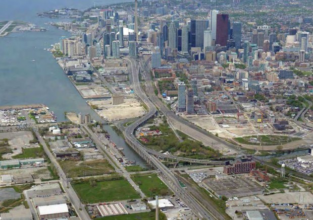
“Writing at the blog Architect This City about the Gardiner debate, transport planner Darren Davis of Auckland, New Zealand, gives a simple four-part explanation for what happens to traffic when a major roadway gets removed or altered. Some people change their routes. Some shift their travel times to hit the road earlier or later. Some switch from cars onto public transit or another mode. And some—typically the case for non-work travel—just don’t make the trip at all.
At the end of his recent op-ed favoring a teardown, Globe and Mail architecture critic Alex Bozikovic asked: “But are we building a city? Or a highway?” Toronto won’t live or die based on the Gardiner decision, but it will be answering that critical question.”
One should tear it down for the opportunity for citizens to be close to the waterfront.
FiveThirtyEight:

“Our analysis showed that the single best predictor of whether someone said his or her area was urban, suburban or rural was ZIP code density. Residents of ZIP codes with more than 2,213 households per square mile typically described their area as urban. Residents of neighborhoods with 102 to 2,213 households per square mile typically called their area suburban. In ZIP codes with fewer than 102 households per square mile, residents typically said they lived in a rural area.2 The density cutoff we found between urban and suburban — 2,213 households per square mile — is roughly equal to the density of ZIP codes 22046 (Falls Church in Northern Virginia); 91367 (Woodland Hills in California’s San Fernando Valley); and 07666 (Teaneck, New Jersey).
Other factors played minor roles in predicting how respondents described where they live. Residents of very small cities and towns rarely said they lived in an urban area, even if their neighborhood was quite dense. Residents of lower-income neighborhoods with older housing stock often said they lived in an urban area, even if it was lower-density. Residents of lower-density ZIP codes with lots of businesses sometimes called their neighborhoods urban; so did residents of lower-density, higher-income ZIP codes that are next to higher-density ZIP codes. But, in general, ZIP code density alone gets us most of the way to predicting whether people say they live in an urban, suburban or rural area.”
Density makes a place vibrant. Density makes a city work. Density is the word and our answer to make better communities. Holly Whyte said "we are going to have to work with a much tighter pattern of spaces and development, and that our environment may be the better for it."
We need to confront the need for density. I've denied and deluded myself that density was not the main issue. I've used words like 'compact', 'vibrant', and 'urban'. What is meant is more people per unit area, as well as mixed use and class.
Higher density is better for a city. Again, Holly Whyte:
“Density also has an important bearing on the look and feel of a neighborhood. If it is urban it ought to be urban. Most of our redevelopment projects are too loose in fabric. They would look better, as well as being more economical, if the scale were tighten up... concentration is the genius of the city, its reason for being. What it needs is not less people, but more, and if this means more density we have no need to feel guilty about it. The ultimate justification for building to higher densities is not that it is more efficient in land costs, but that is can make a better city.”
Urban Milwaukee:

“One of largest-scale urban redevelopment programs ever undertaken in the United States is the Atlanta BeltLine, a sustainable redevelopment project in Atlanta, GA. The project is converting 22 miles of disused Civil War-era railroad tracks encircling the city into a new transit greenway – a walkable green space – that links over 40 neighborhoods across the city like never before. The project is still in its early stages, but has already stimulated dramatic changes in people’s understanding of where they live and how they interact with their space. With plans underway to incorporate the city’s existing subway system, its new streetcar, and a system of multi-use trails across the city, the BeltLine is fast becoming one of Atlanta’s defining features.
The project’s origin is just as remarkable. The BeltLine began as a “kernel of an idea,” the subject of a Georgia Tech graduate student’s 1999 Master’s thesis on architecture and urban planning. Now an urban designer at Perkins+Will, Ryan Gravel’s original vision for the BeltLine has expanded beyond what anybody imagined in the project’s early days.
“Today the vision…include[s] ideas like 1,400 acres of new parks, a linear arboretum, public art, new streetscapes, brownfield remediation, significant investments in affordable housing, and a list that continues to grow,” says Gravel.
The BeltLine made its public debut in 2001 and began its implementation in 2005. Though still in the early stages of development – worst-case projections are for a 2031 completion date – it’s already had an enormous impact on the city.
“It is not only changing the physical form of the city, it’s changing the way we think about this place we live in and the decisions we make about living here,” says Gravel.”
The Conversation:
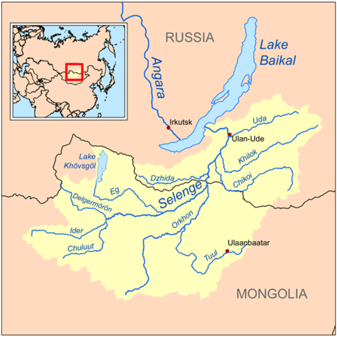
“Mongolia is hoping a massive dam on its largest river could provide much needed power and water for the country’s booming mining industry. However environmental groups are concerned that the hydroelectric power plant and a related pipeline project will do immeasurable environmental damage to oldest and deepest freshwater body in the world: Lake Baikal...
he Shuren Hydropower Plant, planned on the Selenga River in northern Mongolia, was first proposed in 2013 and is currently the subject of a World Bank-funded environmental and social impact assessment. In tandem, Mongolia is also considering building one of the world’s largest pipelines to transport water from the Orkhon River, one of the Selenga’s tributaries, to supply the miners in the Gobi desert 1,000km away.
By far the largest and most important of the 350-plus rivers that flow into Lake Baikal is the Selenga River, which contributes almost 50% of the lake’s water. The Selenga and its tributaries cover a vast area, much of it in northern Mongolia, and the catchment of Lake Baikal is bigger than Spain. The river enters Lake Baikal through the Selenga Delta, a wetland of internationally recognised importance.
The delta is crucial to the health of Lake Baikal. Its shallow waters are a key spawning ground for Baikal’s many endemic fish and is on the migratory route for millions of birds every year. It also filters out impurities flowing through the river before they reach the lake.”
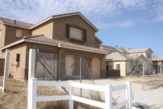
Strong Towns:

“A small town in Minnesota just gave an extended middle finger to one of the state’s most impotent bureaucracies. What is setting up is a school yard brawl between two underweight, skinny greasers with switchblades. Could be a lot of slapping and name calling, but if things go horribly wrong there is the potential that someone gets their throat slit.
Detroit Lakes is a town very similar to my hometown of Brainerd, with the primary distinction being that their auto-based, Ponzi-scheme development blowout happened within the city limits where here in Brainerd that mess was absorbed in the neighboring (competing) city of Baxter. In a grass is greener kind of way, I’ve always perceived them to be doing a little better than we are here. I’m probably wrong.
The current dispute between Detroit Lakes and the Minnesota Department of Natural Resources (DNR) is over an $11.8 million hotel and restaurant very near Detroit Lake.”
Charles Marohn is right to be infuriated with Minnesota's shoreland density requirements for cities -- all Minnesota citizens should be disappointed. The State's shoreland development standards are old. These standards are outdated with regard to lake protection, and they're inconsistent with good land use development principles and practices. When the Minnesota DNR attempted to revise the 1970-80s era standards several years ago, Governor Pawlenty dismissed them because, perhaps rightly, the public and local governments might not have accepted the shoreline buffer provisions that were proposed to protect water quality. Those proposed standards would have also allowed cities to use their own density standards provided that the area was served by sewer and proper stormwater controls. In Lakeshore Living, we speak to the changes that are necessary and how we could use sound place-making principles and good bottom-up community design. Charles Marohn helped me, a lake ecologist, better understand Strong Town principles. Thanks Charles!
The Atlantic:

“It’s tempting, if you haven’t seen the varied stages of this process, to imagine that some cities just “naturally” have attractive and successful downtowns, and others just don’t happen to. It’s like happening to be located on a river, or not.
But in every city we’ve visited with a good downtown, we’ve heard accounts of the long, deliberate process that led to today’s result. The standard discussion will go: “See this restaurant [bar / theater / condo / Apple store with surrounding retail outlets]? Ten years ago, you wouldn’t have [dreamed of coming here at night / seen anyone but crack addicts / been able to rent a condo, or wanted to].” We’ve heard variations of this account so often we now feel a little let down if we don’t get the “this used to be a crack house” speech when visiting a nice hotel or downtown tech-company headquarters...
In every place we’ve been, every one we’ve talked with about downtown recovery stresses the crucial importance of getting people to live there.”
How do you get people to live there? It often requires investing or restoring amenities.
New York Times:

“For more than a century, California has been the state where people flocked for a better life — 164,000 square miles of mountains, farmland and coastline, shimmering with ambition and dreams, money and beauty. It was the cutting-edge symbol of possibility: Hollywood, Silicon Valley, aerospace, agriculture and vineyards.
But now a punishing drought — and the unprecedented measures the state announced last week to compel people to reduce water consumption — is forcing a reconsideration of whether the aspiration of untrammeled growth that has for so long been this state’s driving engine has run against the limits of nature.”
Great pictures and a story that asks difficult questions challenging our paradigm of technical solutions to limits of nature.
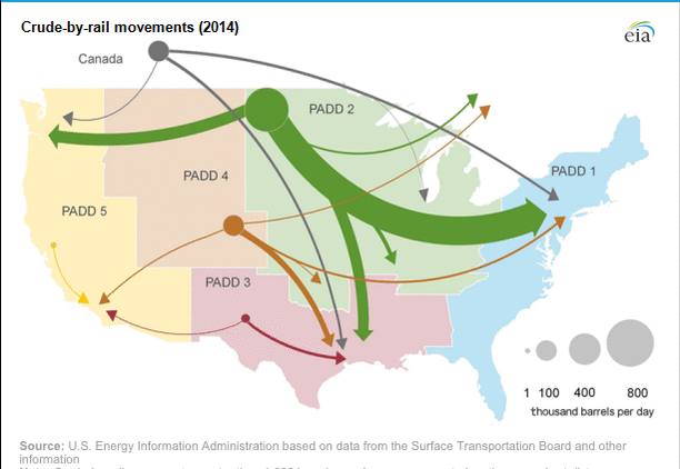
Quartz:

“There are myriad other projects on the table designed to do exactly what Keystone XL was designed to do: transport Canadian tar sands oil to refineries. Those pipelines, both in the US and Canada, are being designed to move the oily bitumen produced from the tar sands to refineries in Texas and eastern Canada, and to ports on the Pacific Coast where the oil could be shipped to Asia.
Combined, the pipelines would be able to carry more than three million barrels of oil per day, far in excess of the 800,000 barrels per day that TransCanada’s Keystone XL is designed to carry.
Canada is sitting on about 168 billion barrels of crude oil locked up in the Alberta tar sands northeast of Edmonton—a trove of carbon-heavy fossil fuels bested in size only by oil reserves in Venezuela and Saudi Arabia. Today, the roughly two million barrels of tar sands oil produced each day in Alberta is sent to refineries in the US and Canada via rail or small pipelines, none of which are adequate to carry the 3.8 million barrels of oil per day expected to be produced in the oil sands by 2022.”
Alana Semuels, writing for the Atlantic:

MyBiggestFan, Flickr
“LAS VEGAS—A decade ago, home builders put up thousands of new spacious stucco homes in the desert here, with marble countertops, ample square footage, and walk-in kitchen cupboards.
Then the recession hit, the values of these homes plummeted, and economists talked of the overbuilding of Las Vegas.
Now, though, developers are building once again, on projects derailed during the recession, including master-planned communities such as the 1,700-acre Skye Canyon, the 2,700-acre Park Highlands, the 1,900-acre Inspirada, and 555 acres of luxury living in an area called Summerlin.
The homes being built here and in many cities across the country look very similar to the ones built during the boom. Some, in fact, are even bigger. The average single-family home built in 2013 was 2,598 square feet, 80 feet larger than the average single-family house built in 2008, and 843 feet larger than homes built in 1978, according to Census Bureau data...
It may be surprising to hear that so little has changed in the homebuilding industry since the recession, especially in Las Vegas, one of the epicenters of the housing bust. After all, low gas prices aside, surveys suggest that both Boomers and younger generations are interested in living in more urban places where they don’t have to spend so much time in the car getting to and from work. They also don’t mind smaller homes, especially if they’re close to public transit or retail or restaurants. And studies have shown that sprawl has negative health impacts: People who live in far-out suburbs walk less, eat more, and exercise less than those who live in urban environments.”
Derek Thompson, writing for CityLab - The Atlantic:

Matthew Paulson
“How has the city stayed so affordable despite its wealth and success? The answers appear to involve a highly unusual approach to regional governance, one that encourages high-income communities to share not only their tax revenues but also their real estate with the lower and middle classes.
In the 1960s, local districts and towns in the Twin Cities region offered competing tax breaks to lure in new businesses, diminishing their revenues and depleting their social services in an effort to steal jobs from elsewhere within the area. In 1971, the region came up with an ingenious plan that would help halt this race to the bottom, and also address widening inequality. The Minnesota state legislature passed a law requiring all of the region’s local governments—in Minneapolis and St. Paul and throughout their ring of suburbs—to contribute almost half of the growth in their commercial tax revenues to a regional pool, from which the money would be distributed to tax-poor areas. Today, business taxes are used to enrich some of the region’s poorest communities.
Never before had such a plan—known as “fiscal equalization”—been tried at the metropolitan level. “In a typical U.S. metro, the disparities between the poor and rich areas are dramatic, because well-off suburbs don’t share the wealth they build,” says Bruce Katz, the director of the Metropolitan Policy Program at the Brookings Institution. But for generations now, the Twin Cities’ downtown area, inner-ring neighborhoods, and tony suburbs have shared in the metro’s commercial success. By spreading the wealth to its poorest neighborhoods, the metro area provides more-equal services in low-income places, and keeps quality of life high just about everywhere.
For decades, Minneapolis was also unusually successful at preventing ghettos from congealing. While many large American cities concentrated their low-income housing in certain districts or neighborhoods during the 20th century, sometimes blocking poor residents from the best available jobs, Minnesota passed a law in 1976 requiring all local governments to plan for their fair share of affordable housing. The Twin Cities enforced this rule vigorously, compelling the construction of low-income housing throughout the fastest-growing suburbs. “In the 1970s and early ’80s, we built 70 percent of our subsidized units in the wealthiest white districts,” Myron Orfield said. “The metro’s affordable-housing plan was one of the best in the country.””
Dave Levitan, writing for Conservation Magazine: Conservation this Week:

Scorpions and Centaurs; Flickr
“Cities are going to get bigger. With more than half the world now living in urban areas, and that percentage growing steadily, that means the concrete and steel will have to stretch out into areas that are currently forest and farm and grass. But just letting that process happen without a plan is likely to be a very bad idea.
A study published in the journal Landscape and Urban Planning simulated the urbanization process in the Piedmont region of North Carolina out to 2032. The question the authors posed was, essentially, what land will suffer in favor of the ever-growing city?
“The application of conservation planning scenarios in land change modeling is often implemented by simply treating priority areas as protected, essentially removing them from eligibility for development,” the authors wrote. “However, full protection of all priority resources is highly unlikely in urbanizing areas.” By understanding what types of policies are likely to result in the best use of land, that type of failed prohibition might be avoided.”
“Monica A. Dorning, Jennifer Koch, Douglas A. Shoemaker, and Ross K. Meentemeyer
Abstract
Land that is of great value for conservation can also be highly suitable for human use, resulting in competition between urban development and the protection of natural resources. To assess the effectiveness of proposed regional land conservation strategies in the context of rapid urbanization, we measured the impacts of simulated development patterns on two distinct conservation goals: protecting priority natural resources and limiting landscape fragmentation. Using a stochastic, patch-based land change model (FUTURES) we projected urbanization in the North Carolina Piedmont according to status quo trends and several conservation-planning strategies, including constraints on the spatial distribution of development, encouraging infill, and increasing development density. This approach allows simulation of population-driven land consumption without excluding the possibility of development, even in areas of high conservation value. We found that if current trends continue, new development will consume 11% of priority resource lands, 21% of forested land, and 14% of farmlands regionally by 2032. We also found that no single conservation strategy was optimal for achieving both conservation goals. For example, strategies that excluded development from priority areas caused increased fragmentation of forests and farmlands, while infill strategies increased loss of priority resources proximal to urban areas. Exploration of these land change scenarios not only confirmed that a failure to act is likely to result in irreconcilable losses to a conservation network, but that all conservation plans are not equivalent in effect, highlighting the importance of analyzing tradeoffs between alternative conservation planning approaches.”
Jane Jacobs's 1958 essay in The Exploding Metropolis:
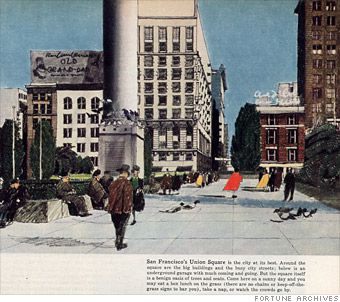
“This year is going to be a critical one for the future of the city. All over the country civic leaders and planners are preparing a series of redevelopment projects that will set the character of the center of our cities for generations to come. Great tracts, many blocks wide, are being razed; only a few cities have their new downtown projects already under construction; but almost every big city is getting ready to build, and the plans will soon be set.
What will the projects look like? They will be spacious, parklike, and uncrowded. They will feature long green vistas. They will be stable and symmetrical and orderly. They will be clean, impressive, and monumental. They will have all the attributes of a well-kept, dignified cemetery. And each project will look very much like the next one: the Golden Gateway office and apartment center planned for San Francisco; the Civic Center for New Orleans; the Lower Hill auditorium and apartment project for Pittsburgh; the Convention Center for Cleveland; the Quality Hill offices and apartments for Kansas City; the downtown scheme for Little Rock; the Capitol Hill project for Nashville. From city to city the architects’ sketches conjure up the same dreary scene; here is no hint of individuality or whim or surprise, no hint that here is a city with a tradition and flavor all its own.
These projects will not revitalize downtown; they will deaden it. For they work at cross-purposes to the city. They banish the street. They banish its function. They banish its variety...”
Jane Jacobs received a grant from the Rockefeller Foundation to expand this critique of modernist planning and design on downtowns into a book, and in 1961 The Death and Life of Great American Cities was published.
Charles Marohn, writing for Strong Towns:

“Concurrent with the advent of the automobile came many other technological and social changes that allowed modern humans to dream big. Cheap fossil fuels. Advanced communication technology. Centralization of decision-making. Proactive management of the national economy. We attacked the problems of the traditional city with the fervor of a great nation empowered to think differently.
We developed different building types. Different building styles. We came up with different ways of arranging things on the landscape and different ways of connecting these places. We developed an entirely new system of regulation to rapidly replicate this new pattern along with the financing mechanisms and economic incentives to make it happen.
This all seems normal to us today – for most of us, it is all we have ever known – but it is critical to understand that, in the course of human history, the American development pattern is one of the greatest social, cultural and financial experiments ever attempted. The knowledge we apply daily in this experiment wasn’t developed by trial and error over the slow grind of centuries. ”
If into a social experiment you go without adapting, only pain will result when the experiment becomes unsustainable. Then the dark side will cloud everything.
Alana Semuel, reporting for the Atlantic:
Alana Semuel
“Fully 88 percent of Atlanta’s poor live in the suburbs, according to Confronting Suburban Poverty in America, by Elizabeth Kneebone and Alan Berube of the Brookings Institution. Between 2000 and 2011, Atlanta’s suburban poor population grew by 159 percent, while the city’s poor population remained essentially flat.
It’s not just Atlanta—across much of the country, poverty is increasingly a problem found in the suburbs. The number of poor in the suburbs surpassed the number of poor in the cities in the 2000s, and by 2011, almost 16.4 million suburban residents lived below the poverty line, according to Kneebone and Berube.”
Once you start down the path of decline, forever will it dominate your destiny, drain your coffers it will.
Eric Jaffe, writing for CityLabs:
Alan Parker, Flickr.com
“Some of the most trusted planning tools used to manage vehicular traffic have shown themselves to be pretty harmful to city life in certain ways. A metric known as Level of Service, which aims to minimize automobile delay at an intersection, can act as a huge obstacle to public transportation projects. A design book calling for 12-foot lanes, an engineering staple across the country, can speed up car flows and endanger public safety as a result.
It might be time to add one more established tool to the questionable list: the Trip Generation Manual from the Institute for Transportation Engineers, a common guide that tells traffic planners how many car trips will be generated by a new commercial or residential development project.”
In a dark place we find ourselves, and a little more knowledge with a little less dependence on assumptions lights our way.
Bill Lindeke, writing for Streets.mn:

“I was surprised when I got to my buddy’s place because, though it was in the middle of nowhere, my friend’s house wasn’t a house per se. Rather, he’d bought an attached townhome that was part of a long row of similar complexes in a brand new greenfield development, complete with sidewalks and quasi-porches and a pleasant almost grid-like street network.
Looking out at the sidewalks, I turned and asked my friend, “So where’s do you walk to?”
He looked at me blankly. “Um. People walk their dogs?”
The useless sidewalks in my friend’s strange middle-of-nowhere quasi-urban neighborhood got me thinking, so I started looking around for places where you have relatively urban densities, but no urban diversity. There are lots of these places, and not just in the suburbs. It doesn’t make any sense, but there you have it. Let’s meet some of them!”
We must unlearn what we have learned with our failed suburban experiment.
Matt Hickman, writing for Mother Nature Network:

Living Building Challenge
“So what exactly are the standout sustainability features at the pedestrian- and cyclist-friendly McGilvra Place Park? And how did they help transform a lonely traffic median in the middle of Seattle into the world’s first Living Park?
In addition to preserving 11 century-old London plane trees that were already at the site, replacing water-intensive turf with native vegetation, increasing accessibility and bringing in the aforementioned ping-pong tables, it’s fascinating to learn how the park’s new features meet the incredibly stringent Living Building Challenge requirements.”
Mind what you have seen. Save you it can.
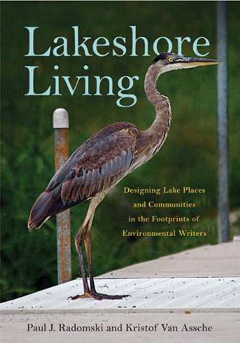
Lakeshore Living and Walleye. This blog builds upon these books, which provides insight into relevant aspects of environmentally-sensitive lakeshore living and the life of walleye. This blog may provide some meaning for people interested in improving lakeshore living and understanding walleye and fisheries management.

Categories:
Tags: