Richard D. Kahlenberg: Minneapolis Saw That NIMBYism Has Victims

CityLab:

Robert Fullerton: Getty

Social scientists broadly agree that bans on multifamily housing are bad for housing affordability, bad for racial inequality, and bad for the environment. Yet there has been a broad political consensus that changing these long-entrenched policies is out of the question. In neighborhood debates about planning and zoning policy, the loudest voices usually belong to people who are satisfied with the status quo. The vaguest of not-in-my-backyard objections from wealthy homeowners—who attend public meetings and regularly vote—are often enough to thwart the construction of new housing.

What’s happened in Minneapolis is different—and so unusual that my colleagues at the Century Foundation and I undertook a detailed review of how and why reformers prevailed. In Minneapolis, housing advocates have succeeded by shifting the focus of public discussion toward the victims of exclusionary zoning. More important, advocates also showed public officials and their own fellow citizens just how numerous those victims were.

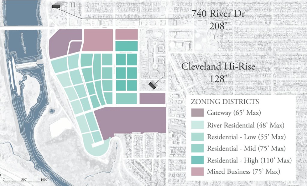
Despite being a city of 425,000 residents, Minneapolis until now has banned duplexes, triplexes, and larger apartment buildings from 70 percent of its residential land; in New York City, by comparison, just 15 percent of residential land is set aside for single-family homes. The city council’s Minneapolis 2040 plan up-zones the city to allow two- and three-family buildings on what had been single-family lots, tripling the potential number of housing units in the city.

This new zoning law is now the standard in Minneapolis. See City Pages

Walker Orenstein: Status of Enbridge Line 3 Pipeline

Minnpost:

Calgary-based Enbridge is close to building a crude oil pipeline through northern Minnesota’s lake country after its plans received key approval from state energy regulators this year. But despite the green light from the Public Utilities Commission, Enbridge has yet to break ground for its $2.6 billion, 337-mile Minnesota portion of the Line 3 project. That’s because the company still faces several government hurdles and legal challenges to moving the pipeline ahead...

Environmentalists opposed to the route worry a spill could pollute the Mississippi River’s headwaters or other nearby lakes and waterways in the region. The pipeline is also expected to run through some remote territory, increasing concern that it would be difficult to quickly catch and fix a spill.

In an email, Juli Kellner, a spokeswoman for Enbridge, said the final route through Minnesota “reflects years of environmental and cultural studies, plus extensive engagement efforts with Tribes, individual landowners and local communities resulting in more than 50 route changes of the line.”

Jay Walljasper: A Green Neighborhood on the old Ford Plant Site

CityLab:

Today, all that remains of the Ford factory is an expansive tract of bare land in the middle of the middle-class Highland Park neighborhood, where a lone smokestack juts up from the old steam plant. The top layer of heavily contaminated dirt has been scraped away and piled up in mounds underneath plastic covers, waiting to be removed. Diesel shovels and other heavy equipment dot the grounds.

But the Ford site is poised for a dramatic rebirth: Over the next 20 years, these 122 acres overlooking the Mississippi River are slated to grow into a dense mixed-use neighborhood designed to be a showpiece of energy efficiency, smart design, ecological stormwater management, and enlightened economic development. Last fall, the St. Paul City Council approved the Ford site master plan, developed by the city’s planning department after an intensive 11-year process. The plan maps out the vision for a transit-accessible community for up to 7,200 residents, an eco-village within the city that boasts a grid of bike- and pedestrian-friendly streets, abundant green space, and jobs for 1,500 workers—almost as many as the old Ford plant had at its height. Twenty percent of the development’s housing will be priced for lower-income residents.

It is a reasonable plan. One hopes that the car-free elements are expanded as development progresses.

Leidy Klotz: Little-Known Behavioral Scientist Who Transformed Cities

The Behavioral Scientist:

Cris Tagupa/Unsplash

“Why are you architects not interested in people?” Ingrid Gehl asked her new husband, Jan. “What do you think about the fact that your architecture professors take their photos at four o’clock in the morning … without the distraction of people in the photos?”

In the early 1960s, and in many cases still today, these were forbidden questions, particularly among those we think of as designers—architects, city planners, and engineers. Then and now, designers consider human needs for health, survival, safety, and comfort through building codes and best practices. Psychological needs are only an afterthought—at best.

Ingrid, however, was no conventional designer—she was a psychologist. And by entertaining such questions, Ingrid and her husband took the first steps on a journey to create city spaces for the full range of human needs. The Danish couple’s ideas have since made life better in cities like New York, Moscow, Buenos Aires, Sydney, and London. Of course, many parts of many cities still seem optimized for buildings and cars. But the story of Ingrid and Jan is a model for what partnerships between behavioral scientists and designers can look like today.

In the 1960s and 1970s, William Whyte was studying human behavior in New York City and applying similar thinking in the United States.

Bruce Stutz: A City's Green Makeover

Yale Environment 360:

Benjamin Franklin, Philadelphia’s favorite son, described his city’s stormwater problem well: By “covering a ground plot with buildings and pavements, which carry off most of the rain and prevent its soaking into the Earth and renewing and purifying the Springs … the water of wells must gradually grow worse, and in time be unfit for use as I find has happened in all old cities.”

When he wrote this in 1789, many of Philadelphia’s water sources, the scores of streams that ran into the Schuylkill and Delaware rivers, were already cesspools of household and industrial waste. As they became intolerable eyesores and miasmic health hazards, the city simply covered them with brick arches, turned the streams into sewers, and on top constructed new streets, an expanding impervious landscape that left the rains with even fewer places for “soaking into the Earth.” ...

The city is now in the seventh year of a 25-year project designed to fulfill an agreement with the U.S. Environmental Protection Agency (EPA) to reduce by 85 percent Philadelphia’s combined sewer overflows. These overflows occur when heavy rains overwhelm the capacity of the city’s sewage treatment plants to handle the flow from both storm and sanitary sewers, forcing the diversion of untreated effluent into the system’s river outfalls. But rather than spending an estimated $9.6 billion on a “gray” infrastructure program of ever-larger tunnels, the city is investing an estimated $2.4 billion in public funds — to be augmented by large expenditures from the private sector — to create a citywide mosaic of green stormwater infrastructure.

Integrated into the city’s green spaces, streetscapes, and public and private buildings, this green infrastructure ranges from simple home rain barrels and downspout planters to complex bioretention swales underlain by drains, filled with sandy soil, and planted with resilient species of grasses, perennials, shrubs, and trees. Along with rain gardens, tree trenches, green roofs, and urban wetlands, this infrastructure will, as one study put it, “optimize and engineer the landscape” to mimic and restore its natural hydrologic regime. In the end, Philadelphia hopes by the mid-2030s to create the largest green stormwater infrastructure in the United States.

Bill Lindeke: Minnesota's Capitol versus Wisconsin's

streetsMN:

It’s time once again for the Minnesota legislative session, the annual period of time when laws are debated at length, stall out completely, and then get decided at the very last minute with no prior knowledge of what’s in them. For those who are into politics, it’s a fun time.

But I want to take today and discuss an open secret about the Minnesota state capitol located in Saint Paul, Minnesota: it’s terrible urbanism...

I always contrast the lifeless Minnesota State Capitol in my mind with the amazing example of the Wisconsin State Capitol in Madison. Both buildings are beautiful, but the key difference is that the Wisconsin building is surrounded by vibrant urbanism. It is in every way the gold standard for how a state capitol and its surrounding government buildings can fit seamlessly into a walkable city.

Mimi Kirk: A Rational Housing Solution

The Atlantic:

When Kol Peterson moved to Portland, Oregon, in 2010, affordable housing was a priority, as it was for many newcomers in this city’s booming real-estate market. He looked at two frequently discussed options for high-cost cities—tiny houses on wheels and communal living—but decided on another option: accessory dwelling units, or ADUs—also known as “granny flats,” or basement or garage apartments...

“By 2020, ADUs will take off in tens of cities,” he said. “This doesn’t mean there will be an explosion of them overnight, but the concept will become more popular in the next couple of years.”

Peterson recently wrote a book, Backdoor Revolution: The Definitive Guide to ADU Development, that walks potential ADU builders through the planning and construction process, and tackles the social, economic, and environmental issues that relate to such housing.

James Kunstler: The Infinite Suburb is a Joke

The American Conservative:

Jun Cen

In their visions of the future, the elite graduate schools of urban planning lately see a new-and-improved suburbia, based on self-driving electric cars, “drone deliveries at your doorstep,” and “teardrop-shaped one-way roads” (I think that means cul-de-sacs) as the coming sure thing. It sounds suspiciously like yesterday’s tomorrow, the George Jetson utopia that has been the stock-in-trade of half-baked futurism for decades. It may be obvious that for some time now we have lived in a reality-optional culture and it’s vividly on display in the cavalcade of techno-narcissism that passes for thinking these days in academia.

Exhibit A is the essay that appeared last month in The New York Times Sunday Magazine titled “The Suburb of the Future is Almost Here,” by Alan M. Berger of the MIT urban design faculty and author of the book Infinite Suburbia — on the face of it a perfectly inane notion. The subtitle of his Times Magazine piece went: “Millennials want a different kind of suburban development that is smart, efficient, and sustainable.”

Note the trio of clichés at the end, borrowed from the lexicon of the advertising industry. “Smart” is a meaningless anodyne that replaces the worn out tropes “deluxe,” “super,” “limited edition,” and so on. It’s simply meant to tweak the reader’s status consciousness. Who wants to be dumb?

“Efficient” and “sustainable” are actually at odds. The combo ought to ring an alarm bell for anyone tasked with designing human habitats. Do you know what “efficient” gets you in terms of ecology? Monocultures.

Kunstler at his best. Suburbia is a high-energy development form -- it can only exist with abundant and cheap energy. Suburbs are scaled-up, jazzed-up hunter-gather type communities. The original hunter-gather communities existed in the wilderness where one lived with one's tribe, and they were likely good places to live. However, our big-sized suburbs exist on our cities' outskirts with unknown and sometime friendly neighbors, eating land, wasting resources, and in troubled times often fostering a culture of fear.

Emily Nonko: The Roots of NYC Subway System Woes

Curbed NY:

New Yorkers now use a transit system in a state of emergency. The past few months have laid bare the enormity of the problems currently facing the century-old subways, from aging infrastructure to a lack of federal dollars available to help make things better.

Much has also been said about how the world’s largest public transportation system has gotten so bad—the lack of funding, of course, but also Gov. Andrew Cuomo’s penchant for prioritizing flashy projects over system maintenance, along with years of mismanagement within the MTA, an agency that’s admitted to misspent funding that doesn’t go toward maintenance.

But start looking at the decline of, and disinvestment in, New York’s rail lines—from the subway to commuter rails like the Long Island Rail Road—and you’ll find that those problems go back much, much further. And, perhaps unsurprisingly, they seem to lead to one man in particular: Robert Moses.

Kate Wagner: The Rise of the McModern

Curbed:

Rachel Sender

From busy rooflines to plastic shutters, mismatched windows to four-car garages, the McMansion has dominated the American suburban residential landscape for almost 40 years without a notable change in aesthetics. Many people know a McMansion when they see one. The typical McMansion follows a formula: It’s large, cheaply constructed, and architecturally sloppy.

How to identify a McModern, as per McMansion Hell:
-Single-family detached home
-Constructed from inexpensive materials, such as vinyl, stucco board, and veneers, rather than traditional materials such as stucco or reinforced concrete
-Contrasting exterior cladding materials and colors
-Attached garage and/or two-story foyer
-Sometimes features non-modern details like Tuscan columns or windows with stylized muntins
-Massing and rooflines may be over-elaborate, combining several roof forms, e.g. terrace, shed, “butterfly,” or “M-shaped”
-May include decorative forms like extruded walls or cantilevers clad in differing materials
-Windows are erratically sized and placed in “artistic” configurations without consideration for overall composition

See more from Kate Wagner at McMansion Hell

Adam Rogers: Apple's New Headquarters is Old Culture

Wired:

You can’t understand a building without looking at what’s around it—its site, as the architects say. From that angle, Apple’s new HQ is a retrograde, literally inward-looking building with contempt for the city where it lives and cities in general. People rightly credit Apple for defining the look and feel of the future; its computers and phones seem like science fiction. But by building a mega-headquarters straight out of the middle of the last century, Apple has exacerbated the already serious problems endemic to 21st-century suburbs like Cupertino—transportation, housing, and economics. Apple Park is an anachronism wrapped in glass, tucked into a neighborhood.

Apple can't be good at everything. Steve Job grew up in a suburb and his formative experiences likely influenced his ideals of corporate headquarters.

Bill Lindeke: Five Reasons to Like St. Paul's Ford Site Plan

streets.mn:

There are about 150 acres of somewhat polluted land on a prime spot in the heart of the Twin Cities metro, right next to a bunch of existing or planned high-capacity transit corridors. And right now demand for smaller, affordable, mixed-use housing is huge — and projected to grow immensely as demographic changes continue. It’s a dream come true for urban planners, and it’s a tabula rasa chance for Saint Paul to build a neighborhood designed around the future.

The land is currently being cleaned up by the Ford company. So far, there have been years of work putting together ideas for the site. the hope is that, once these broad plans are adopted, a Ford will sell the site to a willing developer who will flesh out these guidelines into a detailed proposal.

Here are my five favorite things about the plans so far...

Adam Sneed: Parks People Enjoy

CityLab:

What designers in Canberra, Australia, learned when they decided to spruce up an imposing concrete plaza to make it more attractive to locals. Their interventions weren’t huge, expensive, or particularly novel: Color is the most noticeable addition they made to Garema Place, by way of yarn-bombs, paint, and lighting. They also added vibrant, lightweight tables and chairs that people could move wherever they wanted, and installed a patch of grass to bring a little more nature into the mix…and voilà!

When the new features were added, the number of people stopping to hang out in the area shot up 247 percent, and it wasn’t just adults taking a seat as they passed by. More couples and friends lingered in the plaza, as did more seniors, families, and children. This was a key goal behind the project: Garema Place is known more for its weekend nightlife than for being welcoming to families. The researchers credit that change to the wide mix of interventions...”

Matt Steele: Zoning Contributes to Unaffordability

streets.mn:

There’s an Ethiopian proverb that goes something like, “When spider webs unite, they can tie up a lion.” When it comes to housing, Minneapolitans may have it better than those in Seattle, San Francisco, D.C., and Brooklyn, but a larger and wider slice of Minneapolis is feeling the pinch of fast-rising rents. For some, this even means displacement or possibly even homelessness. This is unacceptable. And it doesn’t have to be this way, because we could eliminate artificial caps on housing supply in Minneapolis, thereby reducing equilibrium rents and making housing more affordable for more people. If every dwelling unit is like a little barely-visible spider web, it may seem like a unit here or two units there won’t make a big difference. But, on the whole, the economics are sound: Rising supply necessarily lowers rents.

No, I’m not going to claim that upzoning is the panacea to housing affordability. But our current zoning code is working against natural housing supply, and that’s working against housing affordability. It seems like such an easy, obvious win to get rid of the barriers to new housing stock in our city.

To understand how our zoning code is restrictive to the point of being harmful to housing affordability, let’s look at a real life example...

The reader comments to this article are worth reading as well.

Tom Neil: Minneapolis Parks -- Priority for Repair

MinnPost:

The map below shows the 106 Minneapolis parks that were recently given priority rankings (out of 157 total neighborhood parks in the city) for maintenance and improvement under the Minneapolis Park and Recreation Board’s new capital and rehabilitation plan. The parks in the darker shade of green are slated for improvements to be made in the next five years; parks in lighter green will be included in future plans. Click on a park to see its overall ranking and the projects that are planned for the park, if known. To search for an address, use the box in the upper-right corner. For more information on how the rankings were determined, see the table...

Good organization of the data on the city parks.

Eric Jaffe: The Biggest Highway Boondoggles

CityLab:

When Texas expanded the Katy Freeway in Houston a few years back, the expectation was that making the massive road even wider would relieve traffic. Some $2.8 billion later, the 26-lane interstate laid claim to being the “world’s widest freeway”—but the drivers who commuted along it every day were no better off. More lanes simply invited more cars, and by 2014, morning and evening travel times had increased by 30 and 55 percent, respectively, over 2011.

The lesson of the Katy Freeway is precisely the one that U.S. PIRG hopes to convey in its new report, “Highway Boondoggles 2,” the sequel to a 2014 effort. Given that expanding highways at great public cost doesn’t improve rush-hour traffic, there are better ways to spend this money, argue report authors Jeff Inglis of Frontier Group and John C. Olivieri of U.S. PIRG. They identify a dozen road projects, costing $24 billion in all, that are “representative” of the problem:

”America does not have the luxury of wasting tens of billions of dollars on new highways of questionable value. State and federal decision-makers should reevaluate the need for the projects profiled in this report and others that no longer make sense in an era of changing transportation needs.”

5 of 12 were highway expansions. More is not better, and often more fails with larger gridlock.

Peter Harnik: Need for Parks

ULI's UrbanLand:

While a number of big-city mayors and even a governor have endorsed the goal of providing parks or other open spaces within a ten-minute walk of residents, adding enough parks to serve all 249 million people living in U.S. cities, suburbs, and urbanized areas—83 percent of the population—will be a challenge.

There is another, concurrent approach to providing Americans with a nearby park: bringing more dwellings to the periphery of existing parks to increase density on their edges. This is what TPL researcher Kyle Barnhart calls, “not only ‘parks for people,’ but also ‘people for the parks.’”

The concept is parallel to the approach taken with transit. It is well established that the expense of building and operating transit lines can and should be earned back through the promotion of transit-oriented development—dense pockets of housing, commercial space, and retail development within 2,000 feet (610 m) of subway stations and major trolley and bus stops. Arlington, Virginia, for example, has won numerous awards—and achieved notable economic success—by closely tying compact residential and commercial redevelopment to six of its Metro stations.

The same logic can hold for park-oriented development. While studies by Smart Growth America and others show that transit is the strongest generator of demand for urban consolidation and density, parks can be high on that list, too. This has been shown in compact redevelopment in such places as Philadelphia (around Hawthorne Park), St. Paul, Minnesota (around Wacouta Commons), and Denver (along Commons and Confluence parks).

Alana Semuels: Highway Teardown Opportunities

The Atlantic:

As some of the highways reach the end of their useful life, cities and counties are debating the idea of tearing down urban freeways and replacing them with boulevards, streets, and new neighborhoods. Though it might sound like a headache, tearing down freeways in city centers can reduce air pollution and create parks and public spaces that bring cities together, according to Shelton.

“The removal of urban interstates is a growing trend in the U.S.,” Shelton and Gann wrote. This trend, if carried to its logical extreme, can yield sites of intervention that hold the promise of remaking the American city.”

It is important for citizens to consider and debate the merits of highway deconstruction. Often it may be the best option for a community.

Casey Jaywork: Anatomy of a NIMBY

Seattle News:

The language is apocalyptic; the tone, desperate. “Cancer,” “canyons of darkness,” “anguish, hopelessness, and loss.”

But these aren’t war-zone dispatches, nor recollections of a natural disaster. They’re public comments from a Seattle City Council’s land-use-committee hearing held earlier this year. It was there that aggrieved homeowners walked up to one of two smooth wooden podiums in City Hall’s Council chambers to vent the vexation they felt as they watched their communities “being torn apart” by development, as Capitol Hill resident the Venerable Dhammadinna put it.

“Elderly homeowners, the gay community, older women, and families are no longer welcome,” she told the Council, referring to the city’s mixed-density residential areas. “Our neighborhoods are shadowed by tall, bulky buildings. Gardens are being cemented, trees cut down. Those who can’t carry their bags of groceries up and down the hills are not invited into this dystopia.”

The testimony was so consistent—or redundant, depending on your position—that a drinking game could have been fashioned from the proceedings: Take one shot whenever someone said “neighborhood character,” two for “transient.”

An interesting article of Seattle redevelopment dynamics and politics. I was struck by the sameness of the issues across many places.

T.R. Goldman: A Subdivision that Reduced Car-Dependency

POLITICO:

Evanston was failing as a suburb, so it reinvented itself as a mini city. Now the city of Chicago wants to follow its lead.

At first glance, downtown Evanston, Illinois, doesn’t look revolutionary—just another gentrifying urban core with the obligatory Whole Foods, the local organic sustainable restaurants serving $14 cocktails, the towering new, high-end luxury apartments filled with stainless steel appliances and granite countertops. The booming downtown feels increasingly hip; this summer it was featured as a “Surfacing” destination in the New York Times Travel Section. “I have everything here,” says Joanne McCall, pausing one evening on her way inside Sherman Plaza, a soaring, 26-story condominium building. “The post office, the dry cleaner, the movies, I work out upstairs, the Whole Foods is over there, the hair dresser over here. And the Uber thing is getting big here.”

It takes, in fact, a few extra minutes in the neighborhood to realize what’s different—and what’s missing. Downtown Evanston—a sturdy, tree-lined Victorian city wedged neatly between Lake Michigan and Chicago’s northern border—is missing cars. Or, more accurately, it’s missing a lot of cars. Thanks to concerted planning, these new developments are rising within a 10-minute walk of two rail lines and half-a-dozen bus routes. The local automobile ownership rate is nearly half that of the surrounding area.

A thorough article on how a city was redesigned for the benefit of citizens rather than for box stores. The article speaks of transit-oriented development, and it should be noted that the term meant mass transit, less car parking spaces, allowance of beneficial high density, and a major zoning ordinance change allowing mixed use and a focus on public benefits,